|
|
|
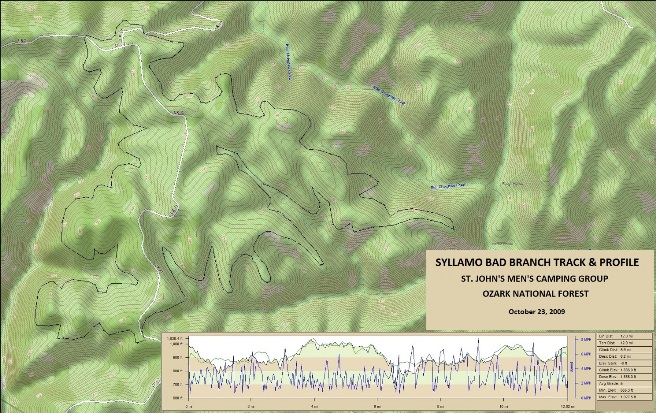
Mountain Biking In ARKANSAS The following is descriptions and photos of the trails Bruce has ridden in Arkansas. These trails were ridden over several years between 2009 and 2015. Scroll down for a complete list of rides and summaries, and use the links in the in the summaries to go to descriptions and photos for the specific trails and rides. Syllamo, Mountain View, AR - Bad Branch Trail: October 23, 2009 with the men from the church as part as a men's camping trip. The Syllamo trail system consists of 5 trails in the Ouachita National Forest and has an IMBA EPIC status. Syllamo, Mountain View, AR - White River Bluff Trail: October 24, 2009, day two of the camping trip with the men from the church. Ouachita NF, Mt. Ida, AR - The Womble Trail: May of 2009, 2012, 2013 and 2015 during the Dallas Off-Road Bicycle Association (DORBA) Camp Clearfork Mountain Bike Festival. The Womble is an IMBA EPIC Bruce first rode in 2009. Ouachita NF, Crystal Springs, AR - The LOViT Trail, West: May 27, 2012 during the Dallas Off-Road Bicycle Association (DORBA) Camp Clearfork Mountain Bike Festival. The LOViT is an IMBA EPIC Bruce first rode in 2012. Ouachita NF, Crystal Springs, AR - The LOViT Trail, East: May 23, 2015 during the Dallas Off-Road Bicycle Association (DORBA) Camp Clearfork Mountain Bike Festival. The LOViT is an IMBA EPIC Bruce first rode in 2012. Syllamo, Mountain View, AR - Bad Branch Trail In October of 2009, the men of the church gathered at Blanchard Springs in the Ozark National Forest for their annual campout. It just so happens that the Blanchard Springs campground is located at the foot of Syllamo Mt., another IMBA EPIC trail. Naturally, Bruce was "in" and even convinced a few of the guys to bring bikes. They rode the Bad Branch and White River Bluff trails. They could have done more, except that it was rather rainy that weekend. The statistics for the Bad Branch ride are provided below along with a map showing the track and profile and statistics. Bruce wasn't using a GPS to log his rides in 2009, so the track and profile is based on a track downloaded from the MTBProject site. The track and profile is for the clockwise direction. Reverse it for a counter-clockwise ride.
Right click on the GPX link above to download the IMBA GPX file for this ride. The GPX file may want to save as an XML file, so if it does, change the extension to gpx before you save it. You can right-click on the image below and use the "Save Target As" option to down-load a 1MB 11x17" PDF version of the map that can be printed. You can also click on the image to open it in a new window and zoom up to 200% for a detailed view.
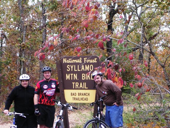
The Bad Branch Trail is rather typical for Arkansas. It is mostly single track through a hardwood forest with long sustained climbs and down-hill runs, and quite a few switch-backs. The photo below shows Dave, Bruce and Dave at the entrance to the Bad Branch Loop.
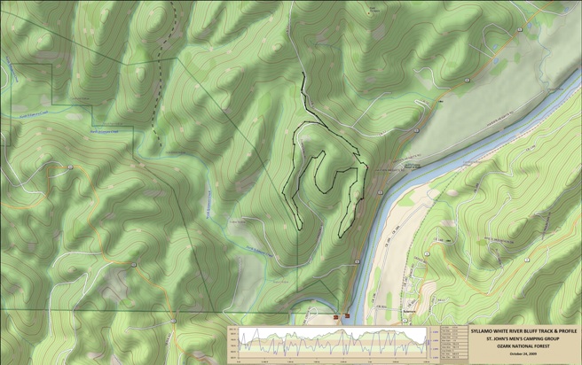
This loop is not highly technical, but is is long and physically demanding if you ride at a fast pace. Climbs are not steep, but some do go on for a good ways. The trail has some sharp rocks in places and I sliced a sidewall near the end of the loop. Fortunately, I had a spare tube, splint and cable ties with me to repair it. Syllamo, Mountain View, AR - White River Bluff Trail The following day, Bruce also rode the White River Bluff Trail during the men's camp-out at Syllamo the weekend of October 23-24 2009. As the name implies, this trail follows the bluff above the White River for part of it's distance.
The statistics for the Syllamo White River Bluff ride are provided
below along with a map showing the track and profile and statistics.
The track and profile is for the clockwise direction. Reverse it for
a counter-clockwise ride.
Right click on the GPX link above to download the IMBA GPX file for this ride. The GPX file may want to save as an XML file, so if it does, change the extension to gpx before you save it. The file is a high-resolution track with points are every 10' created on the Delorme PN-60W GPS. You can right-click on the image below and use the "Save Target As" option to down-load a 1MB 11x17" PDF version of the map that can be printed. You can also click on the image to open it in a new window and zoom up to 200% for a detailed view.
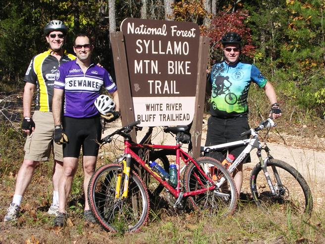
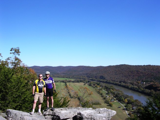
This is the kind of trail on which you will use all your gears. The grades are not impossibly steep, but you will need your lower gears in some places. Gary, Fr. Bob and Bruce are shown below at the trailhead just before starting the White River Bluff Loop ride.
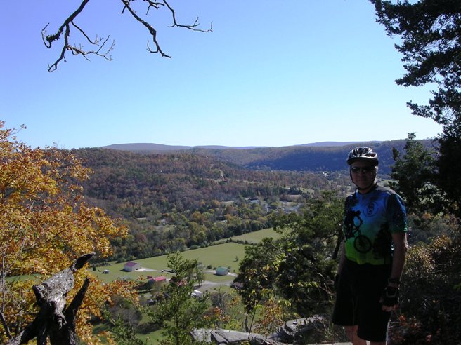
Fr. Bob is in the Sewanee jersey and Gary is in the black and yellow jersey. The photo below is one of the vistas near the beginning of the loop once you get up on the bluff. It is looking "up river".
The following photo is another one further down along the bluff looking "down river", and shows a bit more of the river valley.
The trip was well worth it, and Bruce is planning to go back with a group of "hard core" riders and ride the whole system. There is a fish camp and hotel near the entrance to the trail system that will make a great base of operations. Ouachita NF, Mt. Ida, AR - The Womble Trail In May of 2009, 2012, 2013 and 2015 Bruce attended the Clearfork Mountain Bike Festival sponsored by the Dallas Off Road Bicycle Association (DORBA). This is an annual event at Camp Clearfork in the Ouachita National Forest. The forest is home to several famous trails, most notably the Womble IMBA EPIC trail. It is also home to the Ouachita Trail, famous for the Ouachita Challenge race each year. The trip in 2009 was a rain-out except for a ride Saturday morning. The 2012 trip was just great, although a bit warm.
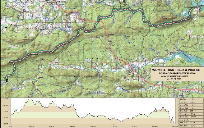
The statistics for the May, 2012 Womble Trail ride are provided below along
with a map showing the track, profile and statistics. This was a
one-way shuttle ride starting at North Fork Lake and finishing at
the fish camp at the west end of Lake Ouachita. The track
and profile is for the eastward direction. Reverse it for a
westward ride.
Right click on the GPX file link above to download a GPX file for this ride. The GPX file may want to save as an XML file, so if it does, change the extension to gpx before you save it. The file is a high-resolution track with points are every 10' created using the Delorme PN-60W GPS. You can right-click on the image below and use the "Save Target As" option to down-load a 1MB 11x17" PDF version of the map that can be printed. You can also click on the image to open it in a new window and zoom up to 200% for a detailed view.
This is the kind of trail on which you will use all your gears, and spend a lot of time in 1-1. The grades are not impossibly steep, but go on for some distance, making it necessary to slow down to a sustainable climbing pace. The trip in 2009 was a rain-out except for a ride Saturday morning. Below is s shot of a few riders taking a break at a creek crossing east of the parking lot on the Womble at Arkansas SR-298.
The photo below shows Bruce (far right) and his buddies Rob, Daniel and Bruce (L-R) at the North Fork Lake entrance to the Womble.
The first part of the ride is fairly technical with some climbs that are physically demanding. A quick check of the profile above bears this out. Below is a photo taken along one of the high sections near the start of the ride.
Below is a shot of the other Bruce coming down the trail near the beginning of the ride.
The mid point of the ride crossed Hwy 298. Other groups were riding from this location and we had them bring a cooler there for our mid-ride resupply stop. Left to right are Bruce, the other Bruce, Daniel and Rob.
Towards the end of the ride, we came to the "bluff". Below is a shot of Rob where the trail comes up next to the edge of the Bluff.
From the Bluff, it is a steep descent and a lot of "in and outs" back to the parking lot. In 2013, Bruce did not ride the entire Womble trail, but instead did an "out-and-back" from the SR-289 parking lot with a few friends. Below is Chi crossing one of several bridges on the trail east of SR-289 in 2013.
Below is a photo of Debbi crossing one of the many small creeks in the area on the 2013 trip.
Ouachita NF, Crystal Springs, AR - The LOViT Trail, West In May of 2009, 2012, 2013 and 2015 Bruce attended the Clearfork Mountain Bike Festival sponsored by the Dallas Off Road Bicycle Association (DORBA). This is an annual event at Camp Clearfork in the Ouachita National Forest. The forest is home to several famous trails, most notably the Womble IMBA EPIC trail. It is also home to the Ouachita Trail, famous for the Ouachita Challenge race each year, and the Lake Ouachita Vista Trail, or LOViT. Bruce rode the western part of the LOViT in 2011 and 2012. In 2015, the eastern part of the trail had been completed from Crystal Springs to Blakely Dam, so Bruce rode the part from the dam back to Camp Clearfork by way of Crystal Springs. The statistics for the LOViT ride are provided below along with a map showing the track and profile and statistics. The 2013 ride was a one-way shuttle ride starting at west trail head near Mt. Ida and ending at Camp Clearfork.
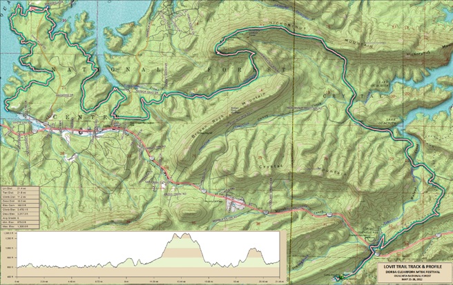
The statistics for the LOViT West ride are provided below along
with a map showing the track and profile and statistics. The track
and profile is for the eastward direction. Reverse it for a
westward ride.
Right click on the GPX link above to download a GPX file for this ride. The GPX file may want to save as an XML file, so if it does, change the extension to gpx before you save it. The file is a high-resolution track with points are every 10' created on the Delorme PN-60W GPS. You can right-click on the image below and use the "Save Target As" option to down-load a 1MB 11x17" PDF version of the map that can be printed. You can also click on the image to open it in a new window and zoom up to 200% for a detailed view.
This is the kind of trail on which you will use all your gears, and spend a lot of time in 1-1. The grades are not impossibly steep, but go on for some distance, making it necessary to slow down to a sustainable climbing pace. As the name implies, the LOViT offers numerous vistas in its trek near the shores of Lake Ouachita. The photo below shows Bruce at one of these vistas along the trail. As the name implies, the LOViT offers numerous vistas in its trek near the shores of Lake Ouachita. The photo below shows Bruce at one of these vistas along the trail.
The first part of the ride is a fairly easy tour through the woods. A quick check of the profile above bears this fact out, and that the real climbing is yet to come. Below is a photo taken along the first part of the trail where he ran into Brandi and a few other riders from DORBA.
Below is a shot of Ryan (L) and Kevin (R), a couple of other DORBA riders in the group.
Next came the climb up Hickory Nut Mt. To say it was brutal would be an understatement. However, at the top, you are rewarded with a great view of Lake Ouachita.
From the overlook, it is down the mountain where you pick up the Charlton Trail back to Camp Clearfork. The Charlton is the second challenge on this ride as you can see from the profile. Ouachita NF, Crystal Springs, AR - The LOViT Trail, East The eastern portion of the LOViT was under construction up until 2014. The initial ride Bruce did was from Crystal Springs out as far as the trail went in 2013. In 2015, the eastern portion has been completed and Bruce rode the LOViT from the Blakely Dam Trail Head back to Crystal Springs.
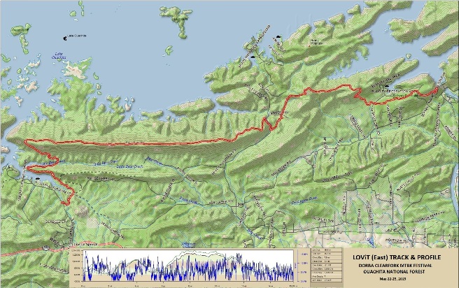
The statistics for the LOViT East ride are provided below along
with a map showing the track and profile and statistics. The track
and profile is for the westward ride in 2015. Reverse it for an
eastward ride.
Right click on the GPX link above to download a GPX file for this ride. The GPX file may want to save as an XML file, so if it does, change the extension to gpx before you save it. The file is a high-resolution track with points are every 10' created on the Delorme PN-60W GPS. You can right-click on the image below and use the "Save Target As" option to down-load a 1MB 11x17" PDF version of the map that can be printed. You can also click on the image to open it in a new window and zoom up to 200% for a detailed view.
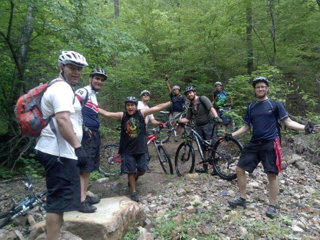
The east part of the LOViT was ridden on two separate occasions, and the following photos are from both rides. The first one is a group photo from the ride in May of 2015. Bruce is on the left.
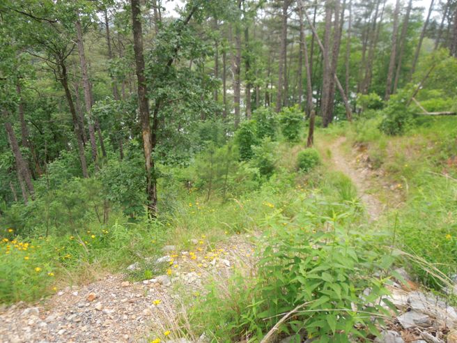
Most of the ride was along the top of Bear Mt. overlooking Lake Ouachita. The photo below is at the end of the mountain where the trail turns and starts its descent to Crystal Springs Campground.
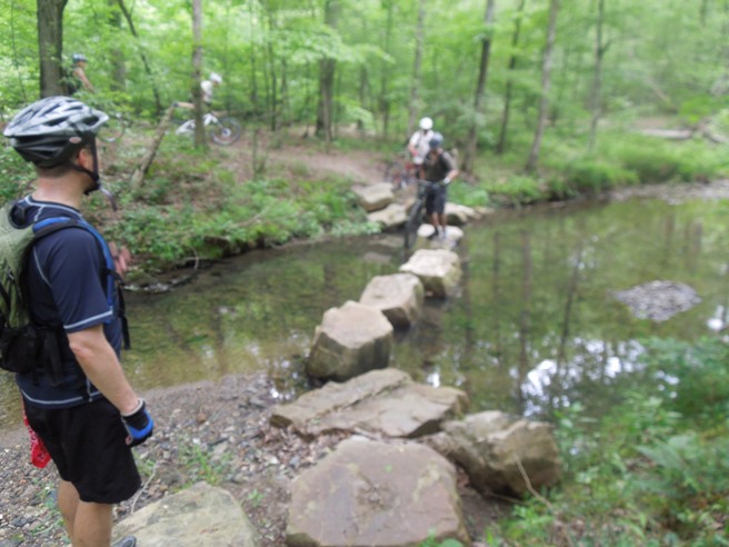
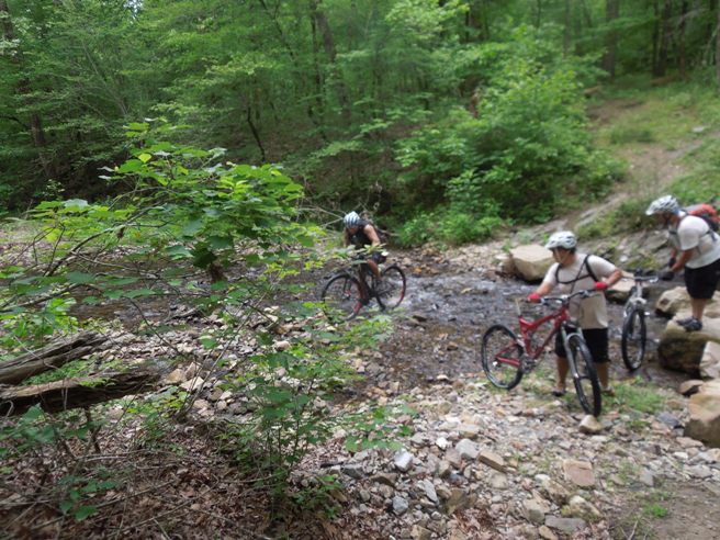
There are several creek crossings along the way. Below is the one at Little Bear Cr. This photo is from the May, 2013 ride.
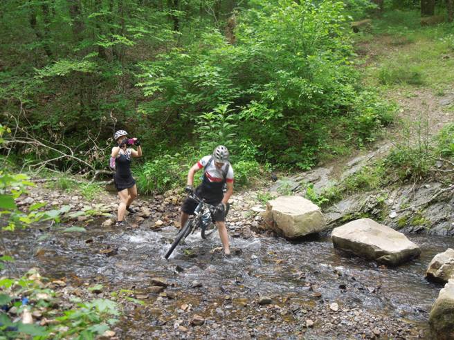
There are several smaller creeks to cross too. Below is a photo of a rider trying to negotiate a down-hill turn and crossing from the 2013 ride. Chi is also taking pictures.
Below is another photo of a rider attempting the crossing in 2013.
Several of the riders successfully made the crossing and celebrated the event on the other side.
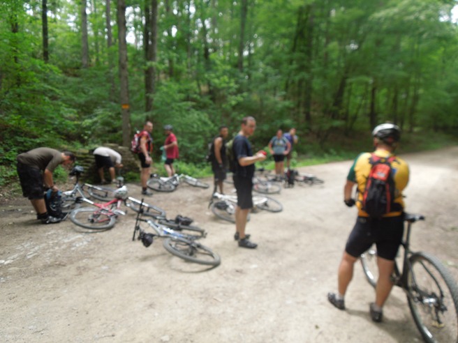
The two sections of the LOViT are connected using a short section of the Hickory Nut Mountain Rd. Below is the 2013 group stopped at the pipe spring on Hickory Nut at the junction of the LOViT and Charlton trails. The Charlton starts behind the stone monument with the pipe spring.
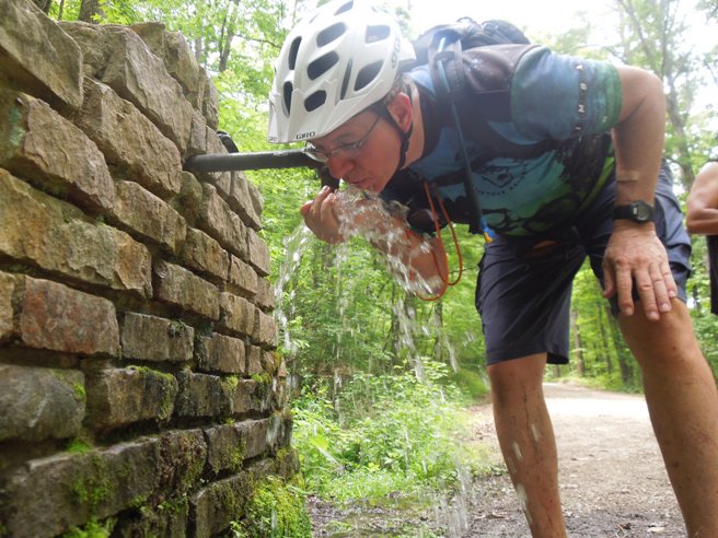
Below is Bruce taking a drink of that cool Ozark natural spring water.
The LOViT is best done in two segments unless you are very fit. Both segments have a lot of climbing and demand a lot of energy. The western section is the more technical of two, and the you would probably need to be a top 1% rider to make the climb up the southwest end of Hickory Nut Mountain. The rest of the trail can be conquered by "mere mortals" in good physical condition. |
|
Version 0.1, September 27, 2015 |